MSR-001 Land For Sale Mekar Sari Tampah Beach Freehold
MSR-001 · Land Offer
Mekar Sari, Praya Barat · Lombok Tengah, Nusa Tenggara Barat — October 2026
Four adjoining freehold certificates totalling 85.90 are in Mekar Sari, Praya Barat, with the Tampah Beach shoreline about 640 m to the south. A quiet bay with an offshore reef, and two institutional-grade villa developments already building on the same water. In a desa the national tourism ministry lists as a tourism village.

Presented by Khairun Nafis · PT Bali Nusa Nirwana
Key facts
| Land area | 85.90 are (8,590 m²) |
|---|---|
| Asking price | Rp 175M per are |
| All-in cost | Rp 16.01B incl. duties |
| Tampah Beach | 664 m to shoreline |
Four certificates, one holding
Boundaries from the ATR/BPN public map service, queried at four points.
Drag to pan, click a parcel for its mapped attributes. Base imagery © Esri, Maxar, Earthstar Geographics.
| Certificate | Title and area |
|---|---|
| 103698047 | Hak Milik · 3,797 m² |
| 103698046 | Hak Milik · 614 m² |
| 00995 | Hak Milik · 2,000 m² |
| 00996 | Hak Milik · 2,179 m² |
| Total 8,590 m² (85.90 are) — all four certificates carry Hak Milik (freehold) status. | |
Parcel boundaries are indicative and must be re-verified at the land office.
View in Google Earth (KMZ)
- 1 Click the button below to download the KMZ.
- 2 Go to Google Earth Web.
- 3 Drag and drop the downloaded file into the browser window.
Tip: Click on a parcel inside Google Earth to see the mapped parcel attributes (NIB, area and title type), then tilt the view to see the land in 3D. The terrain shows the slope and contour lines at 10 m intervals giving an approximate read of elevation. Contours come from public elevation data at roughly 9 m per pixel and are indicative, not a survey.
Download KMZ — parcels and contours
Contains the four parcel boundaries and contour lines in two folders you can switch on and off. Works in Google Earth browser version and Google Earth Pro.
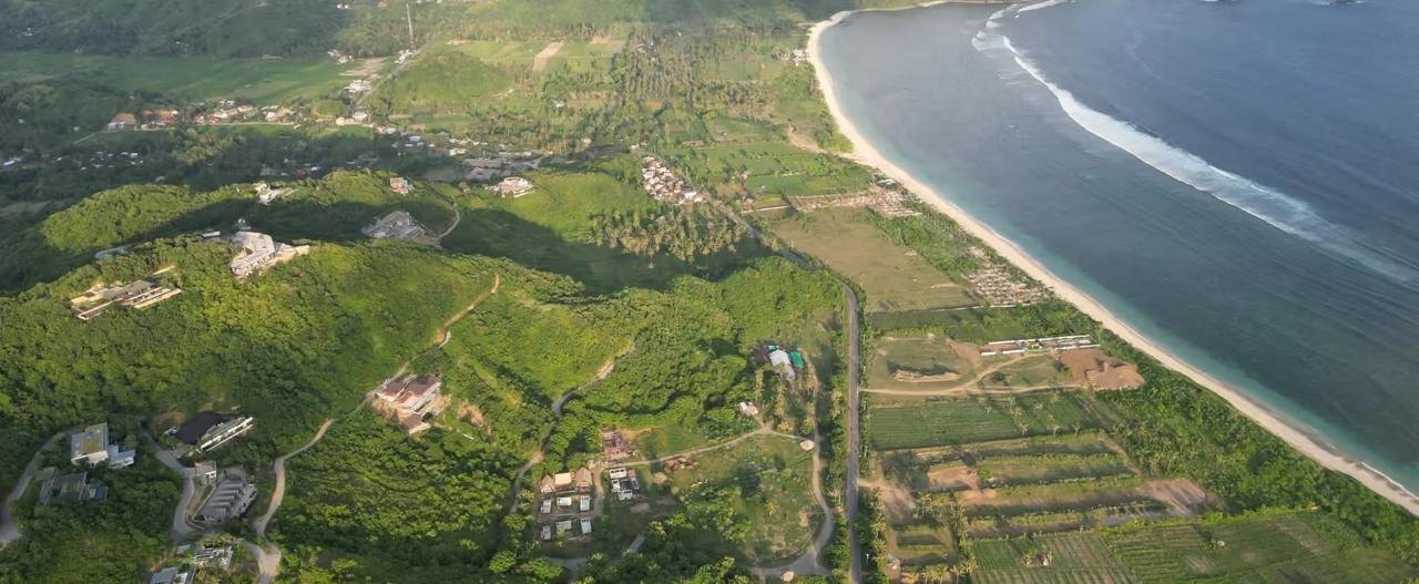
The shoreline is Tampah Beach
The nearest coastline sits about 640 m south of the parcel, and that point is named Tampah Beach. The Pantai Tampah beach itself lies 1.7 km to the south-west. This is the single most valuable thing about the position, and it is why a buyer should look at this land rather than at inland plots anywhere else in the regency.
| Attribute | Detail |
|---|---|
| Rated by visitors | 4.7 of 5 on Tripadvisor |
| Recognition | Tripadvisor Travellers' Choice |
| Character | White sand, reef-protected bay |
| Entry fee | Free, parking about Rp 10,000 |
| Known for | Uncrowded, plastic-free, cleaned daily |
| Swimming | Calm inside the reef, caution at high tide |
What is already being built on this bay
Both projects are on the same bay. Their published plans, prices and target yields are developer statements and are not verified here. What matters for this parcel is simply that two funded, international-facing developments have chosen this shoreline, which raises the profile and the floor for land around it.
| Project | Scale and pricing |
|---|---|
| Tampah Hills Hillside community above Tampah Bay | About 120 ha 120 to 150 villas planned |
| Tampah Beach Villas Beachfront, by Baraca Capital | 80 villas from €220,000, handover Q2 2028 |
| Tampah Hills land, Stage 3 1,700 to 4,800 m² lots | USD 100 to 145 per m² |
What the ground says
Sampled at the first coordinate. Elevation model is Copernicus GLO-90, a 90 m grid.
Terrain & elevation
| Measure | Reading |
|---|---|
| Elevation | 6 metres above sea level |
| Terrain | 5% sampled gradient |
| Relief 100 m | 9 metres |
| Relief 250 m | 55 metres |
| Fall line | SW 216.9° bearing |
| To airport | 30.3 km, about 40 mins |
Proximity
| Proximity | Value |
|---|---|
| Shoreline | 664 m, due S |
| Coast type | coastline |
| Hotels or villas, 3 km | 6 |
| Places to eat, 3 km | 13 |
Climate (5-year mean)
| Climate | Value |
|---|---|
| Mean temperature | 26.6 °C |
| Annual rainfall | 1,852 mm |
| Wettest month | Jan · 329 mm |
| Driest month | Aug · 45 mm |
Administration
| Admin | Detail |
|---|---|
| Desa | Mekar Sari |
| Kecamatan | Praya Barat |
| Kabupaten | Lombok Tengah |
| Kode wilayah | 5202010003 |
| Coordinates | -8.895287, 116.213926 |
Elevation readings are sampled from a public 90 m terrain model and are indicative.
The corridor between Kuta and Selong Belanak
Mekar Sari sits inside kecamatan Praya Barat, the same district as Selong Belanak and the western neighbour of Pujut, which holds Kuta and the Mandalika circuit.
Why Lombok
Why Lombok Tengah
Why Praya Barat
Rp 175M per are per are, in the corridor band
Indicative 2026 zone ranges for South Lombok, quoted per are as land trades here. One are = 100 m².
| Zone | Indicative 2026 range per are |
|---|---|
| Kuta | Rp 300 to 400M |
| Selong Belanak | Rp 150 to 250M |
| Are Guling | Rp 120 to 180M |
| Mandalika | Rp 100 to 150M |
| Mawun | Rp 50 to 80M |
| Bumbang | Rp 30 to 50M |
This parcel's position
Asking: Rp 175M per are / are
Price position: lower half of the Selong Belanak corridor band, and about 42 to 56% below Kuta
Corridor yield context: indicative gross rental yield range quoted for the Selong Belanak zone, with turnkey villa entry from about USD 151,000
Zone ranges are operator-level market estimates, not valuations of this parcel. Beachfront and prime-view plots sit at the top of a range; inland and road-access plots sit lower. This parcel is roughly 664 m back from the shoreline, so compare it against inland plots in the corridor, not against beachfront.
16.01B all in
Budget model at the asking price across 85.90 are.
| Line item | Amount |
|---|---|
| Land, 85.90 are at Rp 175,000,000 | Rp 15,032,500,000 |
| BPHTB, 5% after the Rp 80M deduction | Rp 747,625,000 |
| Notary / PPAT, 1% | Rp 150,325,000 |
| Registration and other, 0.5% budget allowance | Rp 75,162,500 |
| Indicative acquisition budget | Rp 16,005,612,500 |
| Indicative acquisition budget | {TOTAL_ALL_IN} |
| Per-unit | Amount |
|---|---|
| Per are, land only | {PRICE_PER_ARE_LAND} |
| Per are, all in | {PRICE_PER_ARE_ALL_IN} |
| Per m², land only | {PRICE_PER_M2_LAND} |
| Per m², all in | {PRICE_PER_M2_ALL_IN} |
Duties as share of price: 6.5% — BPHTB, notary and registration combined on this model.
Indicative budgeting figures, not an official tariff or quote. BPHTB, notary and registration are estimates and are confirmed at the transaction.
The path to a clean title
Coordinates -8.895287, 116.213926. Availability and price are indicative and subject to change until a sale and purchase deed is signed.
How this information was compiled
Preliminary land screening, not title verification and not a site survey. Site context is sampled at the first accepted input coordinate and is not a separate assessment of each parcel. Parcel boundaries and mapped attributes come from the ATR/BPN public map service and are indicative. Terrain is sampled from Copernicus DEM (GLO-90) via Open-Meteo. Coastline, climate and nearby development come from OpenStreetMap and Open-Meteo. Airport distance is a routing estimate. None of this substitutes for a title search, a licensed boundary survey, or independent legal advice.
Sources
- Sources: ATR/BPN public map service (parcel geometry, NIB, hak, area).
- OpenStreetMap and Nominatim (administrative boundaries, kode wilayah from the Permendagri 72/2019 list, postcode).
- Open-Meteo and Copernicus GLO-90 (elevation, slope, five-year climate).
- OSRM and the OurAirports directory (airport routing).
- Zone price bands and corridor yield context are operator-level 2025 market estimates from South Lombok property market publications.
- Regency and national tourism figures from BPS, ITDC and the Ministry of Tourism.
MSR-001 / Land Offer / Mekar Sari, Praya Barat, Lombok Tengah / October 2026 / PT Bali Nusa Nirwana


No comments:
Post a Comment